- Home
- /
- SAS Viya
- /
- Visual Analytics
- /
- Re: GeoMapping with SAS VA
- RSS Feed
- Mark Topic as New
- Mark Topic as Read
- Float this Topic for Current User
- Bookmark
- Subscribe
- Mute
- Printer Friendly Page
- Mark as New
- Bookmark
- Subscribe
- Mute
- RSS Feed
- Permalink
- Report Inappropriate Content
Can you tell us more about what you are seeing in VA? Are you able to define a geography data item for the custom region?
Can you complete the testing steps documented here?
Thanks,
Sam
- Mark as New
- Bookmark
- Subscribe
- Mute
- RSS Feed
- Permalink
- Report Inappropriate Content
Sam,
It is now working!!
Thank you for holding my hand throughout the process.
The key step I missed was:
Note that the SAS Workspace Server must have access to read this custom map library. Also, a restart of the SAS Object Spawner is required to pick up this autoexec modification.
I got that from Angela's Hall's paper.
Many thanks
David
- Mark as New
- Bookmark
- Subscribe
- Mute
- RSS Feed
- Permalink
- Report Inappropriate Content
Sorry you have had so much trouble with this. I'm going to check with the development team and see if that last step should be added to the documentation.
Thanks,
Sam
- Mark as New
- Bookmark
- Subscribe
- Mute
- RSS Feed
- Permalink
- Report Inappropriate Content
I'm wondering if you can point me in the direction of documentation that explains why the custom map directory is necessary. If VA has access to the directory where my lookup tables are stored, shouldn't I also be able to put my boundary files there? I'm not suggesting this would be a good idea long-term; but, as I was going through the process of modifying lookup tables, I thought I could direct the CENTLOOKUP to read boundary data from VALIB, temporarily. As it turns out, this is not the case.
I'm confused as to why this doesn't work. How will VA know to treat my boundary files differnetly when accessing them from the CUSTMAP directory once it is created? Is it necessary that this directory/library has a certain name? If not, I'm even more confused as to why just placing the boundary data in VALIB doesn't work as I expect.
- Mark as New
- Bookmark
- Subscribe
- Mute
- RSS Feed
- Permalink
- Report Inappropriate Content
Hello jltz83,
Are you following the directions and using the code from the documentation here?
In theory I think it would work to put your files in VALIB. I could be wrong, but I believe the MAPSCSTM directory/library is created for "best practices" reasons to keep your VALIB directory clean.
Sam
- Mark as New
- Bookmark
- Subscribe
- Mute
- RSS Feed
- Permalink
- Report Inappropriate Content
Hi Sam,
I am following the 7.4 Administration Guide, and everything seems to be working properly (i.e., no error message in Report Designer) except no polygons are displayed in the GeoRegion map.
I was just given write permissions on lookup tables, so I was wanting to use VALIB temporarily to make sure that I know how the system works before requesting our IT staff create a new directory. Getting these results is making me wonder whether the name of the custom maps library needs to be exactly MAPSCSTM, some other name (I have seen MAPCUSTM in other documentation), or whether it can be given any name.
Justin
- Mark as New
- Bookmark
- Subscribe
- Mute
- RSS Feed
- Permalink
- Report Inappropriate Content
Thanks Justin. Did you restart the spawner and the webapp server?
I don't see why the custom library would need to have a particular name, provided that you reference the correct libref in your SAS code. "MAPSCSTM" is the name that has been tested.
- Mark as New
- Bookmark
- Subscribe
- Mute
- RSS Feed
- Permalink
- Report Inappropriate Content
We did restart our services the other day, and it's a bit of a hassle because we have to put in a request with our IT department and reload all of our tables. So, I'm hoping to get some of these issues worked out before requesting multiple restarts.
After the unsuccessful attempt a few days ago, I went back through the documentation and made sure my boundary dataset and lookup tables included all fields. I just moved a copy of the VANAMERICA1 dataset and changed the lookup tables to reference the new library location (VALIB). The result is a map with no errors, but also no displayed polygons. I changed the lookup tables back to reference the boundary data in MAPSGFK and everything works fine. I'm not sure why I need to restart the services if I am getting real time responses to the changes I am making to directories. If I pull the boundary data from VALIB when I have the lookup tables pointed there, I get an error. When I put the data back in VALIB, I get the same maps as before: no error and no polygons.
I noticed that our GeographicalMappingService is set up to execute on our OAApp server instead of our VAApp server. (Of course, I do not have permissions to change this.) In an attempt to verify is this was an issue, I restored everything on our VAApp server from backups, created a VALIB on the OAApp server and went through the same process as described above. I get the same results: no errors and no polygons, or an error when the boundary data is missing. It doesn't seem to matter which server the files are referenced from.
- Mark as New
- Bookmark
- Subscribe
- Mute
- RSS Feed
- Permalink
- Report Inappropriate Content
Hi jltz83,
I actually went through many iterations of this, and I think you are right, the directory where you keep the custom boundary dataset is not flexible i.e. you cannot just define it in VA startup and have the CENTLOOKUP reference the relevant datasets.
The safest way is to actually put the customer boundary datasets in MAPSGFK where the prepackaged maps are. Remember to take a backup and restart your servers and obj spawner once done. For some reason just to make things a bit more manual, you cannot just move or create the customer dataset into MAPSGFK on SAS (read-only), so create the datasets in a temp directory and then move them across to MAPSGFK in windows explorer.
Hope this helps, you are very close given that you have not gotten any error messages.
David
- Mark as New
- Bookmark
- Subscribe
- Mute
- RSS Feed
- Permalink
- Report Inappropriate Content
David and Sam,
Thanks for your feedback on this. It seems that our main sticking point with setting up custom maps was the configuration of the GeographicalMappingService stored process. We have a distributed environment and the stored process was set up to execute on an Application Server that was different from (or doesn't have permissions to?) the location where our map directories are located.
After addressing that issue, I can add boundary data to any directory accessble by VA and modify lookup tables on the fly. The one thing that seems to require restart (or updating of the cache) of our system is the additon of the new (State, Province) Name in the Geography dropdown list.
- Mark as New
- Bookmark
- Subscribe
- Mute
- RSS Feed
- Permalink
- Report Inappropriate Content
Hi David,
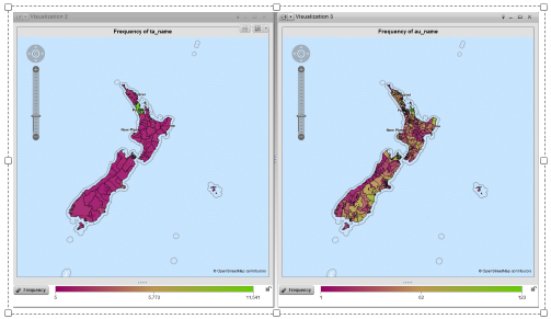
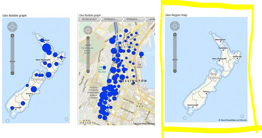
I can see you have the Geo Region Map working in the data explorer. can you let me know if you can have the same geo region map displaying in the report designer?!
As I can have the geo region map displaying in the data explorer but not in the report designer. In report designer, I have the bubble and coordinates maps working but not the geo region.
I will read all the post carefully and see if there was any step that I have missed.
Thanks
REgards
Rita
Thanks
Rita

- Mark as New
- Bookmark
- Subscribe
- Mute
- RSS Feed
- Permalink
- Report Inappropriate Content
Hi Rita,
It works for me except for some formating inconsistencies. It is pretty much the same steps as the data explorer.
David

- Mark as New
- Bookmark
- Subscribe
- Mute
- RSS Feed
- Permalink
- Report Inappropriate Content
Hi All,
After some server restart and upgrades, the maps are not shown.
However, the outcomes between the View the report and edit report are different.
Does anyone knowns when some regions would not be visible in the view but visible in Edit.
View report:
Edit report
thanks!
Cheers,
Rita
- « Previous
-
- 1
- 2
- Next »
See how to use one filter for multiple data sources by mapping your data from SAS’ Alexandria McCall.
Find more tutorials on the SAS Users YouTube channel.


