- Home
- /
- SAS Viya
- /
- Visual Analytics
- /
- Re: How do I use GeoMap feature
- RSS Feed
- Mark Topic as New
- Mark Topic as Read
- Float this Topic for Current User
- Bookmark
- Subscribe
- Mute
- Printer Friendly Page
- Mark as New
- Bookmark
- Subscribe
- Mute
- RSS Feed
- Permalink
- Report Inappropriate Content
Hi... I am trying to acces SAS Visual Analytics from teradatauniversity network. I have two questions.
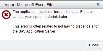
1) I try to upload data from local, a .xlsx format file. It shows an error and says, could be a credential issue with the server
2) I would like to use GeoMap feature. The data set that I am analyzing has the X and Y coordinates in SPC (State Plane Coordinates) system. But I dont see one option of selecting the coordinates format into this. I only see, GDS, British and someother type.
Can someone help me with this.
Thanks for your assistance!!!
Accepted Solutions
- Mark as New
- Bookmark
- Subscribe
- Mute
- RSS Feed
- Permalink
- Report Inappropriate Content
About State Plane Coordinates, you will need to convert those coordinates to another system such as World Geodetic System. SAS/GRAPH has a GPROJECT procedure that can do this. I'm sure there are also third party utilities to convert the coordinates.
SAS is working to add support for State Plane Coordinates in VA for the future, hopefully for next release.
- Mark as New
- Bookmark
- Subscribe
- Mute
- RSS Feed
- Permalink
- Report Inappropriate Content
I have forwarded your question about SPC coordinates to our geomap specialist, hopefully he can provide some advice on how to get your SPC data working in VA.
Thanks,
Sam
- Mark as New
- Bookmark
- Subscribe
- Mute
- RSS Feed
- Permalink
- Report Inappropriate Content
Thanks for the reply Sam, please find the attached capture of the error. To confirm again, I am using a cloud version of the VA tool from the teradatauniversitynetwork.com.
Thanks!!!

- Mark as New
- Bookmark
- Subscribe
- Mute
- RSS Feed
- Permalink
- Report Inappropriate Content
- Mark as New
- Bookmark
- Subscribe
- Mute
- RSS Feed
- Permalink
- Report Inappropriate Content
Not sure Sam, this is my first time use of the tool and my first try of the question to the community. I will try reaching out to teradata, anyways thanks for the reply.
Regards!
- Mark as New
- Bookmark
- Subscribe
- Mute
- RSS Feed
- Permalink
- Report Inappropriate Content
About State Plane Coordinates, you will need to convert those coordinates to another system such as World Geodetic System. SAS/GRAPH has a GPROJECT procedure that can do this. I'm sure there are also third party utilities to convert the coordinates.
SAS is working to add support for State Plane Coordinates in VA for the future, hopefully for next release.
- Mark as New
- Bookmark
- Subscribe
- Mute
- RSS Feed
- Permalink
- Report Inappropriate Content
Thanks for the information Sam, sure will look into the said procedures.
- Mark as New
- Bookmark
- Subscribe
- Mute
- RSS Feed
- Permalink
- Report Inappropriate Content
Sam, you sure on how and from where to access SAS/GRAPH software.
Thanks,
- Mark as New
- Bookmark
- Subscribe
- Mute
- RSS Feed
- Permalink
- Report Inappropriate Content
There are some SPC conversion utilties such as this one:
http://www.ngs.noaa.gov/TOOLS/spc.shtml#
I have no experience with this, but it might help.
See how to use one filter for multiple data sources by mapping your data from SAS’ Alexandria McCall.
Find more tutorials on the SAS Users YouTube channel.


