- Home
- /
- Analytics
- /
- Stat Procs
- /
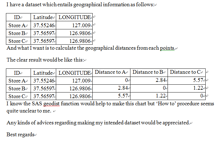
- Asking Advices regarding SAS GEOdist Function
- RSS Feed
- Mark Topic as New
- Mark Topic as Read
- Float this Topic for Current User
- Bookmark
- Subscribe
- Mute
- Printer Friendly Page

- Mark as New
- Bookmark
- Subscribe
- Mute
- RSS Feed
- Permalink
- Report Inappropriate Content
Accepted Solutions

- Mark as New
- Bookmark
- Subscribe
- Mute
- RSS Feed
- Permalink
- Report Inappropriate Content
SQL + geodis() -- sorry I have forgetton. You need check documentation. Here is dummy code.
proc sql;
create table distance as
select a.* ,b.id as _id, geodis(.......) as distance
from have a, have b;
quit;
after that you need transpose your table distance to get final output.
Xia Keshan

- Mark as New
- Bookmark
- Subscribe
- Mute
- RSS Feed
- Permalink
- Report Inappropriate Content
Syntaxt for
GEODIST(latitude-1, longitude-1, latitude-2, longitude-2 <,options>)
so use Ksharps code and bring in the b version of lat and long :
add to the select statement
b.longitude as blong, b.latitude as blat, geodist (latitude, longitude, blat, blong) as distance
you may likely want the store from the b data set as well so you know which distance which would bring up b.id as bstore in the select as well.
- Mark as New
- Bookmark
- Subscribe
- Mute
- RSS Feed
- Permalink
- Report Inappropriate Content
Thanks to all. I finally found 'how to'.
.jpg")
Catch up on SAS Innovate 2026
Nearly 200 sessions are now available on demand with the SAS Innovate Digital Pass.
Explore Now →ANOVA, or Analysis Of Variance, is used to compare the averages or means of two or more populations to better understand how they differ. Watch this tutorial for more.

Find more tutorials on the SAS Users YouTube channel.
-
3 replies
-
07-17-2014 02:54 AM
-
3469 views
-
3 likes
-
3 in conversation
-
