- Home
- /
- SAS Viya
- /
- Visual Analytics
- /
- Re: Build a Map of Ireland with Counties in SAS VA
- RSS Feed
- Mark Topic as New
- Mark Topic as Read
- Float this Topic for Current User
- Bookmark
- Subscribe
- Mute
- Printer Friendly Page

- Mark as New
- Bookmark
- Subscribe
- Mute
- RSS Feed
- Permalink
- Report Inappropriate Content
Hi
I am trying to build a simple map/graph of the Republic of Ireland, with 26 counties, in SAS VA.
I have been able to build the outline of the a map/graph, with the outline of Ireland using just the ISO two letter code - IE. (I have specified as a geographic variable.
However, I am unsure as to which value to use for the county.
I have created values as below (county/clean county are just value I have use to clean up the county in our own data).
COUNTY | CLEAN_COUNTY | PROVINCE | _MAP_GEOMETRY_ | COUNTRY | ID | REGION | IDNAME | OLDID | ISO_CODE |
CO CARLOW | CARLOW | REST OF LEINSTER | id 1 of maps.ireland | 470 | 1 | I | CARLOW | 1 | IE-CW |
The highlighted varaiables are all taken for the Maps library in SAS (Ireland & Ireland2 datasets).
Can I just us a SAS Map ID variable or are the X/Y co-ordinates for each address required or the county mid-point?
I hope this this makes sense.
thanks for your help
Bill
Accepted Solutions

- Mark as New
- Bookmark
- Subscribe
- Mute
- RSS Feed
- Permalink
- Report Inappropriate Content
Hi Bill,
sorry but no experience with county boundaries, I always use cent coordinates given by Google.
So I store the Log/Lat of the customer and center of country. Then the average of the countries by GeoArea is my lat/log for the GeoArea.
While assigning these Log/Lat coordinates to Customers/Counties/Countries/Area's, I create the drill-down hierarchies.
Anyway I am using 6.3 and will upgrade jan 2015 to 7. Lets see if there are new options..
greetings and good luck.
- Mark as New
- Bookmark
- Subscribe
- Mute
- RSS Feed
- Permalink
- Report Inappropriate Content
Hi Bill,
Please check this previous discussion, maybe it helps you out in a different way. https://communities.sas.com/thread/57062?start=0&tstart=0
You can ask google for the center latitude/longitude by county and use the custom geografics.
Greetings Peter
- Mark as New
- Bookmark
- Subscribe
- Mute
- RSS Feed
- Permalink
- Report Inappropriate Content
Hi Peter,
Thanks for the reply. This is and will be useful.
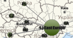
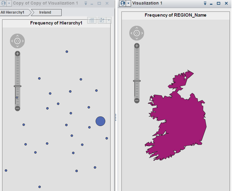
I had managed to get the center latitude/longitude by county and create a custom geography (the large bubble is Dublin) but as you can see below I do not have any county boundaries. The map on the right uses the SAS Region name 'Ireland'
Do you know if SAS VA should display each centroid within its county/SAS defined sub-region boundaries?
I tried to create a hierachy linking country -> county centroid but am not able to get the points to map onto the larger Ireland map.
Thanks
Bill
- Mark as New
- Bookmark
- Subscribe
- Mute
- RSS Feed
- Permalink
- Report Inappropriate Content
Hi Bill,
sorry but no experience with county boundaries, I always use cent coordinates given by Google.
So I store the Log/Lat of the customer and center of country. Then the average of the countries by GeoArea is my lat/log for the GeoArea.
While assigning these Log/Lat coordinates to Customers/Counties/Countries/Area's, I create the drill-down hierarchies.
Anyway I am using 6.3 and will upgrade jan 2015 to 7. Lets see if there are new options..
greetings and good luck.
- Mark as New
- Bookmark
- Subscribe
- Mute
- RSS Feed
- Permalink
- Report Inappropriate Content
Hi Peter.
That is perfect. I will use this method to build the hierachies that I need.
Thanks for your help.
Bill
.jpg")
Catch up on SAS Innovate 2026
Nearly 200 sessions are now available on demand with the SAS Innovate Digital Pass.
Explore Now →See how to use one filter for multiple data sources by mapping your data from SAS’ Alexandria McCall.

Find more tutorials on the SAS Users YouTube channel.
-
4 replies
-
12-10-2014 09:14 AM
-
3314 views
-
4 likes
-
2 in conversation
-
