- Home
- /
- Programming
- /
- Enterprise Guide
- /
- Proc gmap
- RSS Feed
- Mark Topic as New
- Mark Topic as Read
- Float this Topic for Current User
- Bookmark
- Subscribe
- Mute
- Printer Friendly Page
- Mark as New
- Bookmark
- Subscribe
- Mute
- RSS Feed
- Permalink
- Report Inappropriate Content
Hi guys,
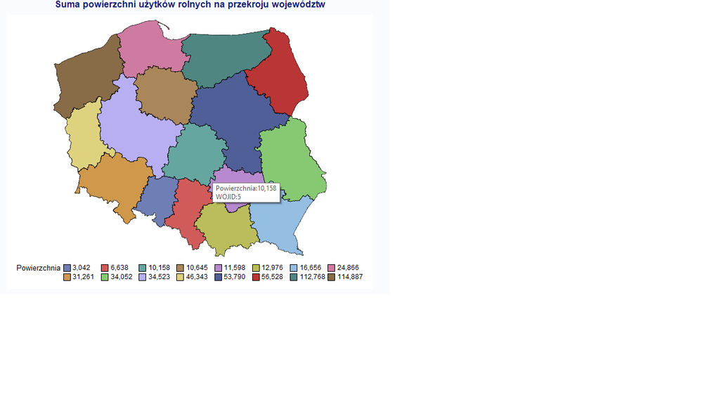
i am wondering how can i change in a gmap procedure the way my regions show their values. I have a dataset which containts of 3 values: an identification variable (numeric), name of the identification variable(text) and the value (numeric). In the gmap procedure I use the id variable to create the map, but i would like to see the text variable when i put my mouse on a particular region. How can it be achieved? Please find the screen shot and the dataset attached. Below the code:
goptions reset=all;
data poland;
set maps.poland;
run;
data poland2;
set maps.poland2;
run;
data poland_woj;
merge poland poland2;
by id;
run;
proc sort data=poland_woj;
by wojid id;
run;
proc gremove data=poland_woj out=woj;
by wojid;
id id;
run;
proc import datafile="C:\Users\Wojtek\Downloads\ROLN_3179_XTAB_20170701180026.xlsx"
out=rolnictwo dbms=xlsx replace;
sheet="tablica";
run;
title 'Suma powierzchni użytków rolnych na przekroju województw';
proc gmap data=rolnictwo map=woj all ;
id wojid;
choro powierzchnia / statistic=sum discrete ;
run;
footnote 'Źródło: Opracowanie własne.';
quit;
title;

- Mark as New
- Bookmark
- Subscribe
- Mute
- RSS Feed
- Permalink
- Report Inappropriate Content
Here's one way to have custom mouse-over text, containing whatever values you want to put into them, using device=png and ods html output:
%let name=map;
filename odsout '.';

goptions device=png;
goptions border;

ODS LISTING CLOSE;
ODS HTML path=odsout body="&name..htm" style=htmlblue;

goptions gunit=pct ftitle="albany amt/bold" ftext="albany amt" htitle=4.0 htext=2.5;
goptions ctext=gray33;

data my_data;
length nazwa $50;
informat Powierzchnia comma8.0;
input WOJID NAZWA Powierzchnia;
datalines;
1 Dolnoslaskie 31,261
2 Kujawsko-Pomorskie 10,645
3 Lubelskie 34,052
4 Lubuskie 46,343
5 Lodzkie 10,158
6 Malopolskie 12,976
7 Mazowieckie 53,790
8 Opolskie 3,042
9 Podkarpackie 16,656
10 Podlaskie 56,528
11 Pomorskie 24,866
12 Slaskie 6,638
13 Swietokrzyskie 11,598
14 Warminsko-Mazurskie 12,768
15 Wielkopolskie 34,523
16 Zachodniopomorskie 14,887
;
run;

/* merge in the numeric id1 (so you'll have something to match with the map) */
proc sql noprint;
create table my_data as
select my_data.*, poland_attr.id1
from my_data left join mapsgfk.poland_attr
on my_data.nazwa = poland_attr.id1name;
quit; run;

/* add html mouse-over text */
data my_data; set my_data;
length my_html $300;
my_html='title='||quote(
 'WOJID: '||trim(left(WOJID))||'0d'x||
 'NAZWA: '||trim(left(NAZWA))||'0d'x||
 'Powierzchnia: '||trim(left(put(Powierzchnia,comma10.0)))
 );
run;


data my_map; set mapsgfk.poland (where=(density<=1));
run;

proc gremove data=my_map out=my_map;
by id1;
id id;
run;

legend1 label=(position=top);

title1 ls=1.5 "Poland Region Map";
proc gmap data=my_data map=my_map all;
format Powierzchnia comma10.0;
id id1;
choro Powierzchnia / levels=4 legend=legend1
 coutline=gray55 html=my_html
 des='' name="&name";
run;

quit;
ODS HTML CLOSE;
ODS LISTING;

Check out this tutorial series to learn how to build your own steps in SAS Studio.
Find more tutorials on the SAS Users YouTube channel.
SAS Training: Just a Click Away
Ready to level-up your skills? Choose your own adventure.


