- Home
- /
- Programming
- /
- Graphics
- /
- weird lines on map of country of Georgia
- RSS Feed
- Mark Topic as New
- Mark Topic as Read
- Float this Topic for Current User
- Bookmark
- Subscribe
- Mute
- Printer Friendly Page
- Mark as New
- Bookmark
- Subscribe
- Mute
- RSS Feed
- Permalink
- Report Inappropriate Content
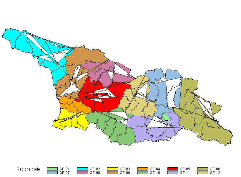
I'm just running some very basic code and wondering what the weird lines are and how to get rid of them. (NOTE this is the country of Georgia, not the state of Georgia).
proc gmap
data=mapsgfk.georgia
map=mapsgfk.georgia;
id id1;
choro id1 ;
run;
quit;
- Mark as New
- Bookmark
- Subscribe
- Mute
- RSS Feed
- Permalink
- Report Inappropriate Content
I think the problem is that this data set has both ID and ID1 variables. Try this:
proc gmap data=mapsgfk.georgia
map=mapsgfk.georgia;
id ID;
choro id1;
run;
quit;- Mark as New
- Bookmark
- Subscribe
- Mute
- RSS Feed
- Permalink
- Report Inappropriate Content
The general behavior results from polygons at one level not being quite closed in regards to the id variable.
Here's a brief example:
data example;
   input id x y id2;
datalines;
1 10 10 1
1 10 15 1
1 15 15 1
1 15 10 1
1 16 27 2
1 25 27 2
1 25 12 2
1 16 12 2
;
run;

proc gmap map=example data=example;
   id id;
   choro id;
run;
quit;


proc gmap map=example data=example;
   id id2;
   choro id2;
run;
quit;
Note that for ID the boundary continues (connects to) the area identified with id2 when using ID.
April 27 – 30 | Gaylord Texan | Grapevine, Texas
Registration is open
Walk in ready to learn. Walk out ready to deliver. This is the data and AI conference you can't afford to miss.
Register now and lock in 2025 pricing—just $495!
Learn how use the CAT functions in SAS to join values from multiple variables into a single value.
Find more tutorials on the SAS Users YouTube channel.
SAS Training: Just a Click Away
Ready to level-up your skills? Choose your own adventure.


