- Home
- /
- SAS Viya
- /
- Visual Analytics
- /
- Not able to view Vietnam Map
- RSS Feed
- Mark Topic as New
- Mark Topic as Read
- Float this Topic for Current User
- Bookmark
- Subscribe
- Mute
- Printer Friendly Page

- Mark as New
- Bookmark
- Subscribe
- Mute
- RSS Feed
- Permalink
- Report Inappropriate Content
Hi,
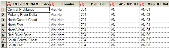
I am new to SAS VA and not very sure on how to create data for "Geo Maps". After exploring on internet I create below data which I used in creating Geo Maps, but nothing worked out. I am not able to see the map. When contacted SAS support, they asked me to check if the Blade 0 server is having internet connection, when checked it was having access to internet.
Please let me know if there is any configuration that is missing which is causing this problem?
Thanks,
Srini

- Mark as New
- Bookmark
- Subscribe
- Mute
- RSS Feed
- Permalink
- Report Inappropriate Content
Hi Srini,
Creating geographical maps in SAS Visual Analytics is pretty straight forward. After loading your data you will need to define a geographical item. SAS VA comes with a set of predefinied geographical lookup values. In your example you could define country as 'Country or Region Names' and REGION_NAME_SAS as 'Subdivision' geo role. If you drag these items to the chart area a geo map should be rendered. By default SAS uses public accessible Open Street Maps but you can also configure alternative ESRI servers if available. And yes, you will need to have internet access configured in order to support geographical maps - sometimes specific proxy or VPN settings could play a role here. SAS Technical Support should be able to help you out here if required.
Hope this helps. Cheers, Falko

- Mark as New
- Bookmark
- Subscribe
- Mute
- RSS Feed
- Permalink
- Report Inappropriate Content
Hi Srini,
I faced similar problems before in having geo map in place. To generate geo map in VA you must consider performing this steps.
make sure you got coordinates (lat & long) for the city in the data source. If yes, then it will only take couple of clicks to produce maps in VA!
If you don't have coordinates, then I would send you SAS geo dataset that contains coordinates in it. All you need to do is to embed that dataset with your source data and produce a new dataset. This approach worked for me.
And yes, you need to have internet connection to see the geo map in VA interface even your VA is setup on standalone pc as SAS VA will coordinate with geo server that you are selecting to setup the map.
Also note: maps will not work offline on iPad and it's works perfectly well when it is on network.
cheers.
satlr
- Mark as New
- Bookmark
- Subscribe
- Mute
- RSS Feed
- Permalink
- Report Inappropriate Content
Thanks for the information Falko & Satlr, I think there is some other issue with the installation/configuration and this problem is still not fixed.
Actually SAS Support is still working on trying to fix this issue. Initially I was not able to see the default map and after SAS Support did some thing I was able to see the the default map in VSE & VSD, "I think they have done some changes in the config file." not sure what exactly they have changed/fixed.
Now when I try to use the county with value "Viet Nam" in VSE & VSD I am getting the following error in the attachment.


- Mark as New
- Bookmark
- Subscribe
- Mute
- RSS Feed
- Permalink
- Report Inappropriate Content
Glad to see that you are able to see the default background map now.
I'm struggling to see the detailed error message in your screenshot but typically these popup dialogs indicate installation or configuration errors. So please continue to work with SAS Technical Support to get this resolved. If errors appear when you start using the geographical visualizations it's often related to the underlying look-up tables. So have SAS Technical Support verify that all tables are in place and have valid content.
Cheers, Falko
- Mark as New
- Bookmark
- Subscribe
- Mute
- RSS Feed
- Permalink
- Report Inappropriate Content
most of the time the geo lookup doesn't work. I would suggest you to include lat and long info in your data column and it must do your job.
Once lat and long info is included, producing a geo map is a simple task in VA.
.jpg")
Catch up on SAS Innovate 2026
Nearly 200 sessions are now available on demand in the Innovate Hub.
Watch Now →See how to use one filter for multiple data sources by mapping your data from SAS’ Alexandria McCall.

Find more tutorials on the SAS Users YouTube channel.
-
5 replies
-
08-11-2014 02:18 AM
-
4378 views
-
6 likes
-
3 in conversation
-
