- Home
- /
- Programming
- /
- Graphics
- /
- Re: Drawing lines between 2 points on a map with GMAP?
- RSS Feed
- Mark Topic as New
- Mark Topic as Read
- Float this Topic for Current User
- Bookmark
- Subscribe
- Mute
- Printer Friendly Page

- Mark as New
- Bookmark
- Subscribe
- Mute
- RSS Feed
- Permalink
- Report Inappropriate Content
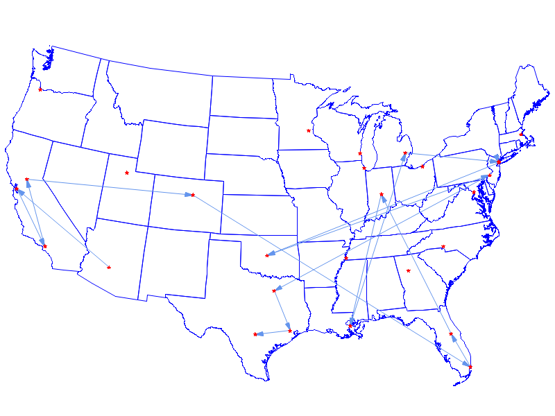
Hi all,
I'm trying to figure out how to draw several lines between different pairs of points on a map, using PROC GMAP or some other mapping procedure. I've already done the prep work using PROC GPROJECT to get my annotation dataset projected in line with my source map dataset, and I can display my map and points with:
proc gmap data=States map=Map0 ;
id state;
choro state / annotate=Loc1 discrete nolegend;
run; quit;
In that code,
States comes from maps.states(where=(state not in(2 15 72))), it's basically the continental US.
Map0 comes from States, and then is processed similar to the dataset "Map" in this example: SAS Maps Online
Loc1 is my dataset of various coordinates I've plotted, and was processed similar to the dataset "Cities" in that same example. It has 30 records of coordinates, with a variable LocID numbered 1 through 30, which is how we identify them internally.
So far so good, and all the points in Loc1 come out exactly where they should be. Now, I'd like to be able to draw lines between the point with LocID=1 and LocID=2, or LocID=5 and LocID=7, or LocID=9 and LocID=22, and so on.
I haven't been able to figure out how to do this, either through PROC GMAP or some other mapping procedure. Does anyone have any suggestions for me to try or examples I could follow?
Thanks!

- Mark as New
- Bookmark
- Subscribe
- Mute
- RSS Feed
- Permalink
- Report Inappropriate Content
You can use an 'annotate' data set to place markers on the map (annotated function='pie') and connect them using annotated lines (function='move' and 'draw').
Here is the simplest example I have...
- Mark as New
- Bookmark
- Subscribe
- Mute
- RSS Feed
- Permalink
- Report Inappropriate Content
That's great, thanks so much! I was able to follow that example and get it to work:
Now, the next thing I need to figure out is if there's a way to calculate the distances of those line segments. That would probably take some data manipulation and using the GEODIST function, right? Or is there a way to do it within PROC GMAP or one of the other mapping procedures?
Thanks again!
- Mark as New
- Bookmark
- Subscribe
- Mute
- RSS Feed
- Permalink
- Report Inappropriate Content
You can use Geodist, but you'll need to make the calculations on the lat/long values *before* you project them.
- Mark as New
- Bookmark
- Subscribe
- Mute
- RSS Feed
- Permalink
- Report Inappropriate Content
One other thing... is there a way to offset multiple lines that collect the same 2 points? For example, if these represent travel between 2 cities, and someone travels between the same two cities more than once, can there be multiple lines next to each other but slightly offset?
- Mark as New
- Bookmark
- Subscribe
- Mute
- RSS Feed
- Permalink
- Report Inappropriate Content
There is a way to offset text, using the annotate 'position' (position='5', position='2', etc), but there is not a built-in way to apply offsets to the drawn graphics (such as pie markers and lines/arrows). You will have to programmatically manipulate the x/y coordinates in your data to do that. (I think this will not be easy.)

- Mark as New
- Bookmark
- Subscribe
- Mute
- RSS Feed
- Permalink
- Report Inappropriate Content
Unless the number of trips is large, you might be able to summarize your data and get counts of duplicate trips. Then factor the number into a line width parameter.
- Mark as New
- Bookmark
- Subscribe
- Mute
- RSS Feed
- Permalink
- Report Inappropriate Content
Thanks to both of you for your responses. What you wrote makes sense, and is along the lines of what I was thinking... it's good to get confirmation on it, definitely.
- Mark as New
- Bookmark
- Subscribe
- Mute
- RSS Feed
- Permalink
- Report Inappropriate Content
Another option, besides the width or color of the line, would be to use alpha-transparent colors (if you have SAS 9.3 or higher). With the alpha-transparent colors, the more lines you overlay in the same location, the more color they will get.
An example of a red alpha-transparent color would be ... Aff000077

Don't miss out on SAS Innovate - Register now for the FREE Livestream!
Can't make it to Vegas? No problem! Watch our general sessions LIVE or on-demand starting April 17th. Hear from SAS execs, best-selling author Adam Grant, Hot Ones host Sean Evans, top tech journalist Kara Swisher, AI expert Cassie Kozyrkov, and the mind-blowing dance crew iLuminate! Plus, get access to over 20 breakout sessions.
Learn how use the CAT functions in SAS to join values from multiple variables into a single value.

Find more tutorials on the SAS Users YouTube channel.
 Click image to register for webinar
Classroom Training Available!
Select SAS Training centers are offering in-person courses. View upcoming courses for:
-
8 replies
-
08-19-2013 12:33 PM
-
7021 views
-
0 likes
-
3 in conversation
-
