- Home
- /
- Programming
- /
- Graphics
- /
- Putting a marker on stitched openstreetmap tiles (Proc GEOCODE/ GPLOT)...
- RSS Feed
- Mark Topic as New
- Mark Topic as Read
- Float this Topic for Current User
- Bookmark
- Subscribe
- Mute
- Printer Friendly Page

- Mark as New
- Bookmark
- Subscribe
- Mute
- RSS Feed
- Permalink
- Report Inappropriate Content
Hi everyone,
I am trying to follow and slightly modify this example of Street-level geocoding on Robert Allison's website. I got the example to work and now I would like to put the marker on a 6x6 square of openstreetmaps tiles. I got it to mostly, but the resolution and quality of the bigger map is greatly reduced. I tried replacing the "goptions xpixels=400 ypixels=400;" line by something bigger such as "goptions xpixels=4000 ypixels=4000;", but all I get is a small low-quality map on a huge white square. What can I do?
To obtain the larger square, I use this image that spans x= 2040-2045 and y=4685-4690 (instead of the original tile that only covers t x=2042 and y=4687. The larger image was obtained by clicking enqueue at this link at bigmaps2 .
Thanks!
Simon
![4687[1].png](https://communities.sas.com/legacyfs/online/7120_4687[1].png)
![LWSweOD[1].png](https://communities.sas.com/legacyfs/online/7118_LWSweOD[1].png)
Accepted Solutions

- Mark as New
- Bookmark
- Subscribe
- Mute
- RSS Feed
- Permalink
- Report Inappropriate Content
Morglum,
You can also use a paper on http://support.sas.com/rnd/papers.
The paper shows you how to use an application I wrote to display an OpenStreetMap background image.
The paper title is; Google-like Maps in SAS
The paper and examples are at (the links are not permanent):
http://support.sas.com/resources/papers/proceedings13/377-2013.pdf
http://support.sas.com/rnd/papers/sasgf13/GooglelikeMaps.zip
.

- Mark as New
- Bookmark
- Subscribe
- Mute
- RSS Feed
- Permalink
- Report Inappropriate Content
Morglum,
That particular example was meant to be very 'minimal' to demonstrate geocoding (that's why it only uses 1 map tile).
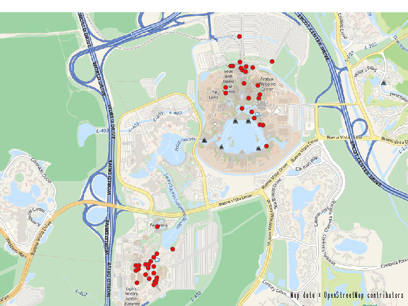
I would recommend using one of my other examples as your starting point. I have many examples that 'stitch' several map tiles together into a larger map, such as this one...
http://robslink.com/SAS/democd68/disney_benchmarks.htm
http://robslink.com/SAS/democd68/disney_benchmarks_info.htm
Or this one:
http://robslink.com/SAS/democd67/myrtle_beach_resorts.htm
http://robslink.com/SAS/democd67/myrtle_beach_resorts_info.htm
- Mark as New
- Bookmark
- Subscribe
- Mute
- RSS Feed
- Permalink
- Report Inappropriate Content
Hi Robert,
Thanks for the links, I hadnt noticed these examples.
- Mark as New
- Bookmark
- Subscribe
- Mute
- RSS Feed
- Permalink
- Report Inappropriate Content
Morglum,
You can also use a paper on http://support.sas.com/rnd/papers.
The paper shows you how to use an application I wrote to display an OpenStreetMap background image.
The paper title is; Google-like Maps in SAS
The paper and examples are at (the links are not permanent):
http://support.sas.com/resources/papers/proceedings13/377-2013.pdf
http://support.sas.com/rnd/papers/sasgf13/GooglelikeMaps.zip
.
- Mark as New
- Bookmark
- Subscribe
- Mute
- RSS Feed
- Permalink
- Report Inappropriate Content
Thanks Darrell, this looks much easier to use than what I hacked based on Robert's examples. thanks for building this!
.jpg")
Catch up on SAS Innovate 2026
Nearly 200 sessions are now available on demand in the Innovate Hub.
Watch Now →Learn how use the CAT functions in SAS to join values from multiple variables into a single value.

Find more tutorials on the SAS Users YouTube channel.
SAS Training: Just a Click Away
Ready to level-up your skills? Choose your own adventure.
-
4 replies
-
08-15-2014 09:09 AM
-
3520 views
-
3 likes
-
3 in conversation
-
